Sea Kayak Navigation: natural ranges and pre-plotted LOPs

In a previous post, we talked about Lines Of Position and about two kinds of LOPs: the shoreline, and compass bearings taken from recognizable landmarks.

But sometimes we just don’t want to break our paddling flow to stop and take compass bearings. And sometimes exuberant waves make shooting and transferring bearings onto a chart that’s bouncing off the trampoline of a sprayskirt deck rather like working on a crossword while riding a Tilt-A-Whirl. At such times, it would be great to have “self-shooting” LOPs. Happily, these exist: they’re called ranges*. They come in two flavours: artificial ranges, which kayakers generally avoid, and natural ranges, which we embrace like the tree-huggers we are.

* Or “transits” if you’re British. They do have a strange habit of coming up with odd new words for things when there are already perfect serviceable ones in English. See truck/lorry, glasses/spectacles, trash can/dustbin, etc.

Read more: Sea Kayak Navigation: natural ranges and pre-plotted LOPs

Artificial ranges are often erected along narrow channels and tricky harbour approaches for the benefit of bigger boats. They’re typically a pair of brightly-coloured trapezoids mounted on frame towers a few hundred metres apart. When the captain of a ship sees them lined up, one directly above the other, it tells them they’re in deep water, in the centre of the marine traffic lane, right where they want to be. When the captain of a kayak sees the same thing, it tells them they’re in deep doo-doo, in the centre of the marine traffic lane, right where they don’t want to be. At best a kayaker may acquire an expensive ticket for interfering with bigger boats; at worst they might be pureed in the prop of an overtaking freighter. So take advantage of your kayak’s much shallower draft and hug the sides of any such vessel traffic lanes you must follow. (But also remember that the wake from big boats will get steeper and more spilly in the shallows.)
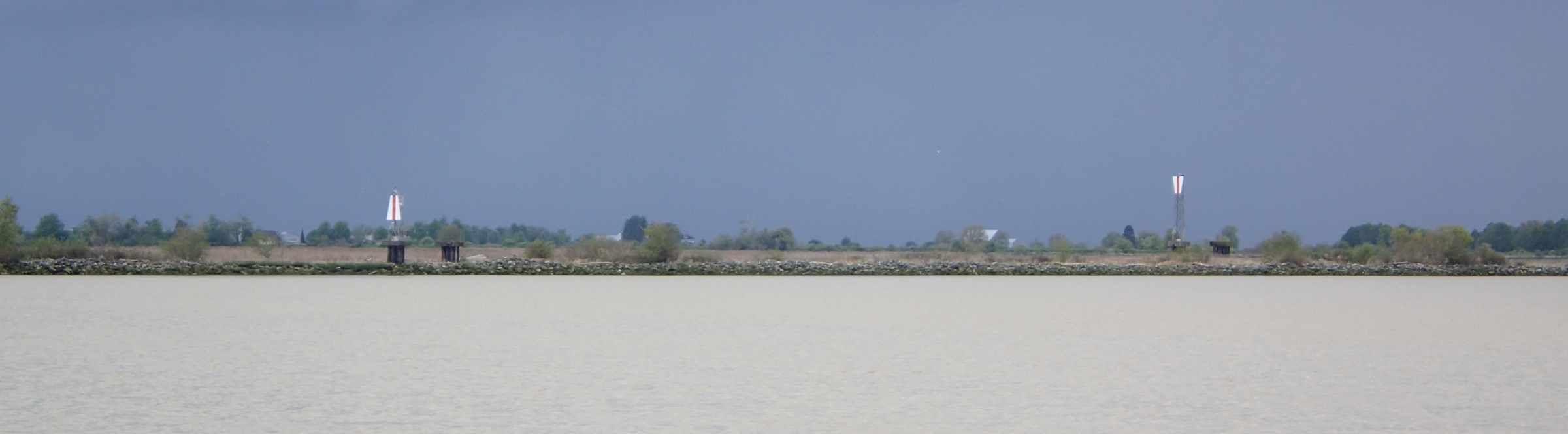
A photo of two navigation ranges, showing their appearance in real life.
A pair of artificial ranges. If you were piloting a ship downriver, you’d want to move far to the left to get the ranges to line up one over the other and put your craft in the deep water channel until you hit the 12A marker shown on the chart section below.

A section of a nautical chart showing how navigational ranges are indicated.
The same ranges, both circled in blue, as they appear on a nautical chart. The bright green circle shows approximately where the photo above was taken.

Natural ranges occur wherever two distinct landmarks line up from the paddler’s point of view. They’re the same sort of landmarks we’d be looking for when taking a compass bearing: the end of an island, a navigation buoy or marker, or the tip of a point.
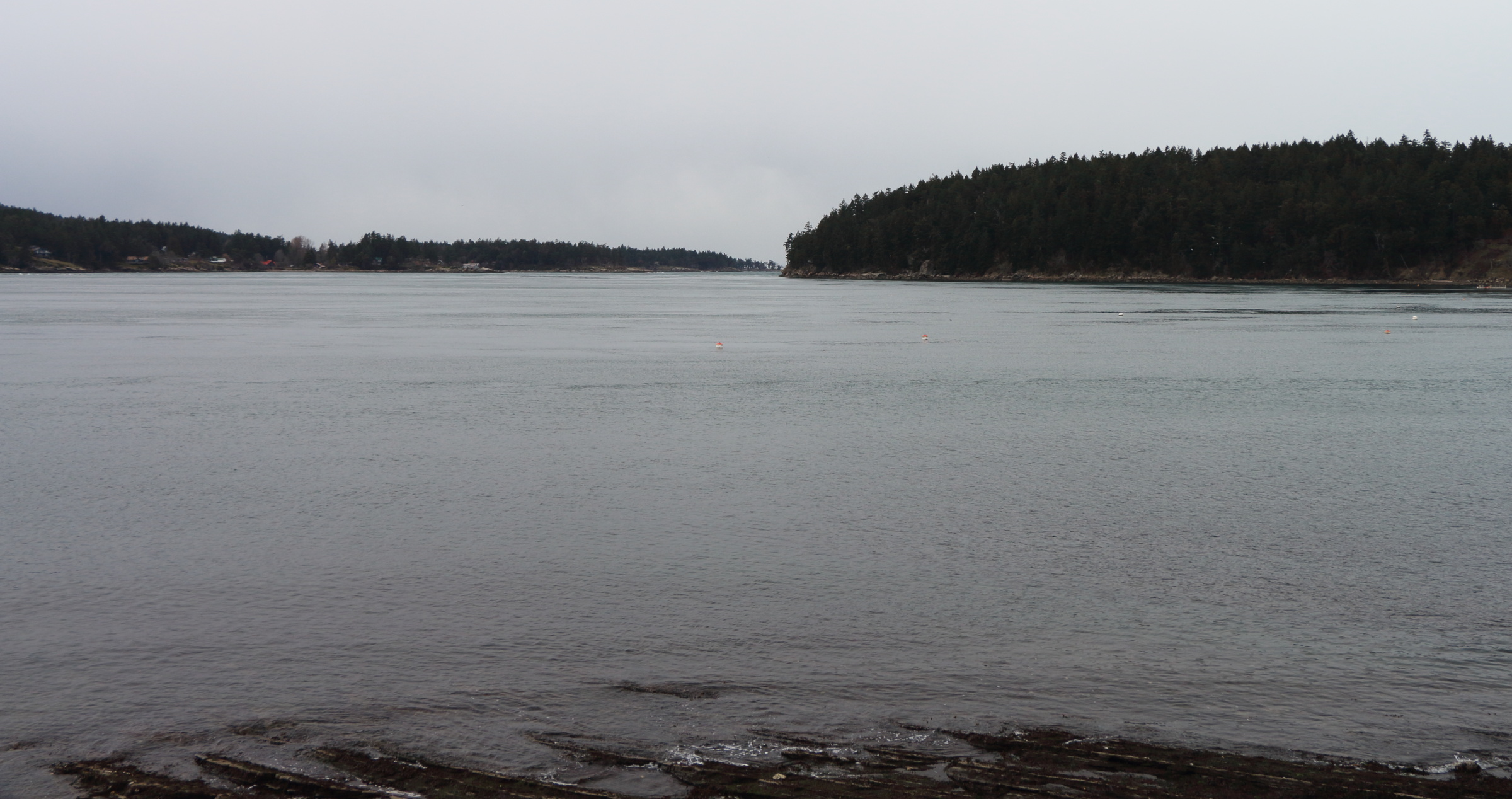
Showing two landmarks as a natural range, creating a Line Of Position. The eastern tip of Gossip Island is lined up with Laura Point on Mayne Island.
Looking north from the shoreline of Miners Bay on Mayne Island. Laura Point, in the middleground on the right, is just overlapping with the eastern tip of Gossip Island, visible in the far background, beyond Rip Point and Burrill Point on the left.
A section of marine chart, with a line drawn showing natural ranges for determining your position.
The natural ranges from the photo above as they line up on a chart. Where the orange line meets the shoreline of Miners Bay is your location. (The large public dock you’d be floating beside would also be a good clue to your location, but you can’t always count on having such infrastructural validation, especially when you’re paddling in remote areas.)

Update March 2024: for another example of a range as an LOP, see the second half of this posting.

You can mix-and-match the intersection points of all types of LOPs to find your position. If all your LOPs are shorelines and natural ranges, you can usually count on them to be pretty accurate (islands and buoys generally don’t move around much). But if one of your LOPs is a compass bearing, it’s not a bad idea to take a second bearing off another object, just to offset errors in taking the first shot and transferring it to the chart.

The next best thing to a natural range as an LOP is a pre-plotted compass bearing. Especially when searching along a shoreline for a not-obvious-from-seaward campsite, a pre-plotted LOP can save a lot of anxious vacillation between “We should spot camp any minute now” and “We’ve overshot it and need to turn around.”

To pre-plot a compass bearing LOP, identify a landmark on the chart you’re confident will be visible as you’re approaching the target campsite in real life. Next, use a ruler or parallel rules to draw a straight line from the campsite to the landmark. Then, using either a hiker’s compass or a string-equipped Davis protractor, determine the magnetic bearing from the campsite to the landmark. (If you do all this at home or ashore in camp, it will be much easier to plot accurate bearings and draw straight lines.)

Pay no attention to the waterfall! We’re navigating by chart and compass, dammit!

For a worked example, let’s go back to the chart we used in this post. But now let’s pretend that instead of making a crossing from Elephant Point to the campsite, we’re paddling north along the shoreline of Granville Bay looking for it. (For purposes of this exercise, we’re going to ignore the fact that in real life, just north of this campsite, there’s a fourteen-hundred foot waterfall thundering down the cliffs as a subtle visual and audio clue to your whereabouts!)
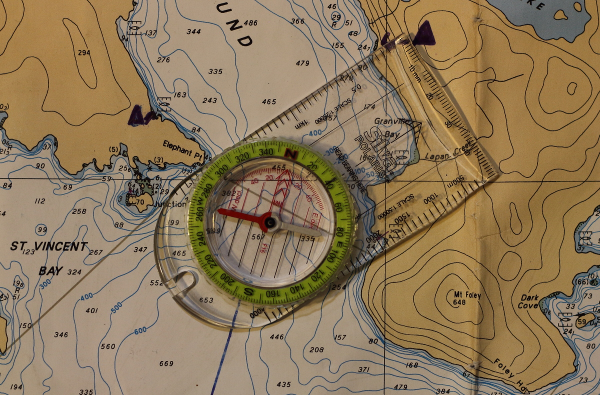
A section of marine chart, with a hiker's compass used as a protractor to determine a bearing from one location to another.
How we determined the bearing from Elephant Point to camp using a hiker’s compass. The “Read Bearing Here” indicator on the compass shows 39°, which we rounded to 40° for practical purposes.

To determine the magnetic bearing from the campsite to Elephant Point with a hiker’s compass on the chart, we could just reverse the procedure shown in the photo above. We’d lay one edge of the compass baseplate running between camp and Elephant Point as before, but this time with the Direction Of Travel arrow pointing the opposite way. Next, we’d turn the compass bezel to make its meridian lines parallel to the blue magnetic North lines on the chart, then note the degrees shown at the Read Bearing Here indicator. But we’ve already done all the same sort of work to determine the bearing from Elephant Point to the campsite, as shown in the photo. That bearing was 40°.

You’ve probably heard the slang, “Doing a one eighty!” to describe turning right around to head straight back to where you came from? It’s a handy way to remember how to work out the reverse (technically called the reciprocal) bearing from B→A when you already know the bearing A→B. In this case, we know the bearing from Elephant Point to the campsite is 40°. So we add 180° (“one eighty”) to 40° and get 220° – the reciprocal bearing from the campsite to Elephant Point.*

*When our original bearing is 180° or less, we add 180 to determine the reciprocal. If the original bearing is greater than 180°, we subtract 180 to get the reciprocal. So if the original bearing had been 270°, the reciprocal would have been 90°. Why this way rather than just always adding or always subtracting? Because, for tediously complicated historical reasons, compasses use 360°circles. So unless you’re Captain Jack Sparrow, your compass won’t show a course higher than 360° or in negative degrees.

A section of nautical chart, with a Davis protractor, showing how to determine the compass bearing from one location to another.
How we determine a bearing from Elephant Point to camp using a modified Davis Protractor. Happily, the indicated bearing is 40°, same as for the compass method above. Alert readers will note that the reciprocal bearing, 220°, is also shown on the edge of the protractor, saving us from having to do the addition or subtraction described in the paragraphs above to get the bearing from camp to Elephant Point.
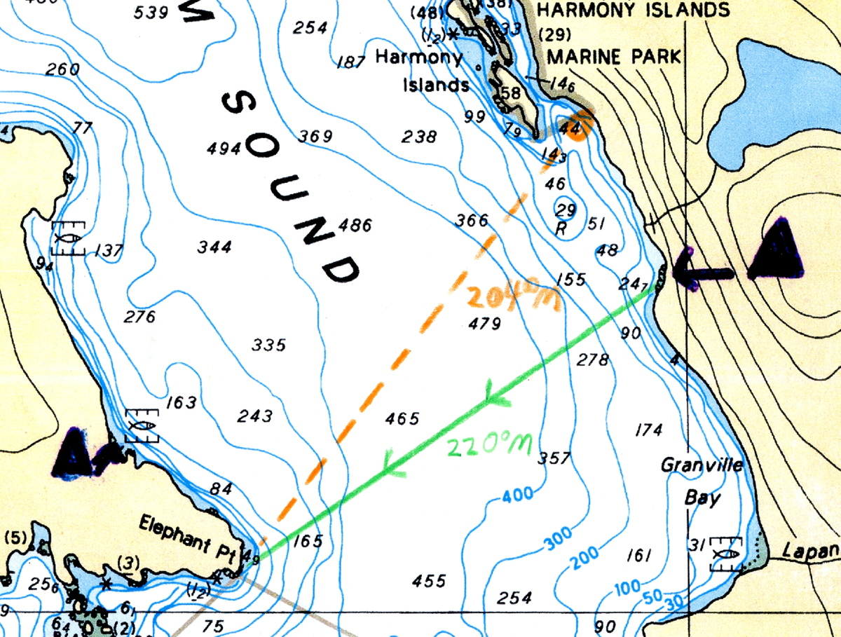
A section of a marine chart, with a pre-plotted bearing line from camp to Elephant Point.
A pre-plotted bearing line in green. The letter “M” after the noted 220° reminds us that this bearing is relative to magnetic North rather than true North. The arrows on the line indicate that the bearing shown runs from camp to Elephant Point.

So now we note the 220° bearing from the campsite to Elephant Point on the green line drawn between the two. As we make our way north up the shoreline of Granville Bay, we periodically take a shot of Elephant Point with our hiker’s compass or our deck compass. If the bearing we get is greater than 220° (I.E. further south), we know we’re not quite there yet; if it’s less than 220° (I.E. further north), we know we’ve overshot.  
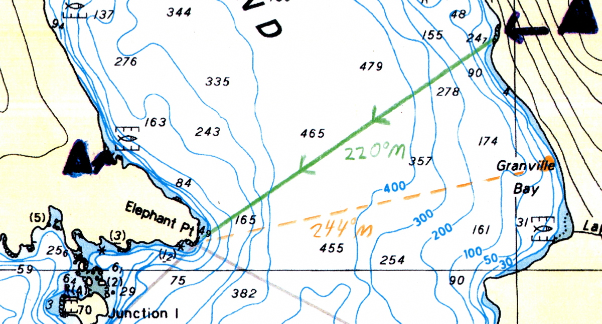
A section of a marine chart with a pre-plotted bearing and a taken bearing south of it.
Imagine we are paddling north along the shore of Granville Bay and are at the orange circle over the end of the word “Granville”. If we were to take a bearing to Elephant Point from here, using either our hiker’s compass or deck compass, we’d get a reading of about 244°. That’s south of the 220° pre-plotted bearing to camp, so we’d know we weren’t there yet.
A section of marine chart showing a pre-plotted compass bearing and a bearing taken from north of it.
If we found ourselves at the location of the orange circle shown here, a compass shot to Elephant Point would give us a bearing of about 204°. That’s north of the 220° pre-plotted LOP to camp, so we’d know we’d gone too far.

It’s good practice to er, practice with LOPs of all kinds even in waters you know like the back of your hand. In fact, especially in waters you know like the back of your hand. That way you’ll quickly recognize any errors you’ve made. Then, hopefully having made all your mistakes in low-consequence situations, you’ll be more confident and competent when applying those skills “for reals” in unfamiliar environments. 

Freshwater Get-away

September 30, 2022

Wanting a trip that was low in cost and complications, we’d opted for a fresh water adventure on Alouette Lake in Golden Ears Park. This avoided the time and deadlines of ferry trips, and let three of us revisit a campsite we hadn’t been to in many years. The expedition consisted of myself, my friend Rhian, and Paul and Nessa, two longtime friends I hadn’t seen in person since before the pandemic.

Rhian and I met the other two expeditioneers at the boat launch on Alouette Lake about noonish. As anticipated, with all the faffing about, we didn’t launch until about 1:30 – just in time for the afternoon wind to have ramped up in our favour.

The fleet ready to launch. The Narrows is visible in the distance as the gap between the taller mountain on the left and the much lower hill on the right. Photo courtesy Paul Richards
Continue reading

Shoulder season on the Sound: Hotham Sound

September 30, 2021

During the drive to Earl’s Cove, heavy rain showers coated the winding road with sheets of water a centimeter deep at times. It was uninspiring, but by the time we arrived at the ferry terminal, it had cleared.

As we approached Saltery Bay on our second ferry ride of the day, we could see Freil Falls (AKA Harmony Falls) in the distance off the starboard side. Shortly afterward, the ferry crew announced whales cavorting off the port side. I snapped a couple of photos of the “you can’t quite make it out, but this black blur is a whale” variety.

The Falls in the distance
A humpback whale spyhops in the distance

By the time we’d landed it was late afternoon. Packing the boats for the first time on any trip always involves a couple of hours of faffing about, especially when you have to go park the car several hundred meters from the put-in after offloading. So we opted to car camp at Mermaid Cove that night, and make a single hop, all by daylight, to our intended destination at Elephant Point the next day.

Continue reading

The Trip That Wasn’t (Part 2)

August 20, 2001

Though I had set my watch alarm for 6:30AM, when my bladder alarm went off at 3:30AM, the wind was howling fiercely through the trees and the barometer had continued to fall. I switched off the clock alarm and slept in until 8AM – which was fine: as it turns out the wind continues to blow against me and whitehorses gallop north through the passage as far as the eye can see.

Continue reading

The Trip That Wasn’t (Part 1)

August 13, 2001

Just getting to the put-in at Prince Rupert from Vancouver has proven to be an epic. I’d driven up from Vancouver to Port Hardy and camped at the Wildwood Campground. The Port Hardy to Prince Rupert ferry which was supposed to leave at 7:30AM on Sunday, August 12, had engine troubles. On the plus side, this meant I didn’t have to get up at 4:30AM to hike from the campground to the ferry terminal. Having driven over to the terminal at 7:30 and dropped my kayak and equipment, I drove back to the campground to park my car long term, and caught a lift back to the terminal in the RV of a friendly Dutch family I’d been chatting with the evening before. 

Continue reading

Paddling The Past: A Fishy Tale

All fishers have tales about The Big One That Got Away; here’s mine about The Big One I Was Glad To Let Go.

One summer in the early oughts of this millennium, four of us took the MV Uchuck from Gold River into Nootka Sound, with our sea kayaks as deck cargo. My wife and I were in my double kayak; my buddy Mike had borrowed my single for the trip, and his partner was paddling another single.

Several days into the trip, we were camped on an idyllic beach with a view of the open Pacific. I borrowed back my single boat and set off in search of supper. Since I was after bottom fish, I was using a hand reel and lure, but had no gaff or net — a nearly tragic oversight, as we shall see.

a sea kayak breaks out through surf
Continue reading

Valhalla Warrior: Solo Kayaking And Hiking On Slocan Lake, Part 2

July 12, 2003
I slept until 7:00, clearly tired out after my hike down from the hills yesterday. What with breaking camp and chatting with my neighbours, I didn’t launch until 10AM.


a sea kayaker paddles down a lakeIt was a perfect morning’s paddling. I came across two sunken barges, easily visible in the clear, fresh water. Like shipwrecks in the sea, these old hulks act as reefs and nurseries for life. They swarm with minnows and a few full-grown trout. Continue reading

Paddling The Past: Solo Sea Kayaking Kyuquot Sound, September 1994 Part 2

the mouth of Johnson Lagoon, a tidal inlet

When the weather and my sickness lift, I return to the entrance of Johnson Lagoon. This time, I have scheduled my approach better: like the gate of a fairytale kingdom that opens to only a few, the current admits me. Not wanting to have to wait half a day for the next slack, I leave the lagoon less than two hours later. Already the current is coursing in a strong ebb. It’s with me, but this is a mixed blessing. While I don’t have to fight against it, it also means there is no retreat once I’ve neared the mouth of the lagoon. The virtues of a kayak optimized for touring—its length, straight line speed, and resistance to turning—are liabilities in what is effectively a whitewater river. It’s like doing a downhill slalom on cross-country skis. After a couple of heart-racing minutes, I am flushed out onto the open sea, very glad not to have left my departure any later. Continue reading

Paddling The Past: Solo Sea Kayaking Kyuquot Sound, September 1994. Part 1

A sea kayak makes its way through heavy rain

As I round the tip of Whitely Island into the long Pacific swell, the bow of my kayak lifts like the head of a stallion eager for rolling, open country after miles of narrow trails. The first leg of my solo paddle from Fair Harbour has run through sheltered channels, and my boat seems to welcome a greater challenge. As do I. For the past several hours, the weather has been what the Irish euphemistically call “soft”—meaning it has varied from gently curling mist to torrential downpours that have hissed on the surface of the water like oil on a hot frying pan. Now the clouds have parted, making the final hour of paddling to Rugged Point pleasantly dry.

Continue reading

Sea Kayaking Around Cape Scott, Part 2

A trip from a time before digital photography.

August 25, 1999 We awoke to a mix of blue sky and clouds, and no rain! With a forecast for 15 knot westerly winds, we made the decision to go for rounding Cape Scott today, and got launched about 9:45AM. Even as we crossed Experiment Bight, we could see foam from swells breaking on rocks north of Cape Scott.

Near the north of the cape, Stania was startled by a sea lion surfacing with an explosive snort just behind her. He torpedoed past our bows, glaring back as he paced us. Just then we noticed, in a kelp bed a couple of hundred feet away, the front flippers of numerous sleeping sea lions, presumably our escort’s harem. By this time we’d passed our closest point of approach to the ladies, so as much as one can tiptoe in a kayak, we tiptoed away, while trying to project soothing vibes to the effect of “We have no designs on your wives, lovely and blubbery though they all are, we’re sure.”

Continue reading