Prologue: this spring, I scored an ancient Current Designs Expedition kayak at the Jericho Sailing Association’s bailiff’s sale (where they auction off boats that have not had the storage fees paid in a while.) For the princely sum of $240, I got a 1992 boat, old enough that it had been made in British Columbia, before Current Designs was sold to an American company and the manufacturing moved out of BC.
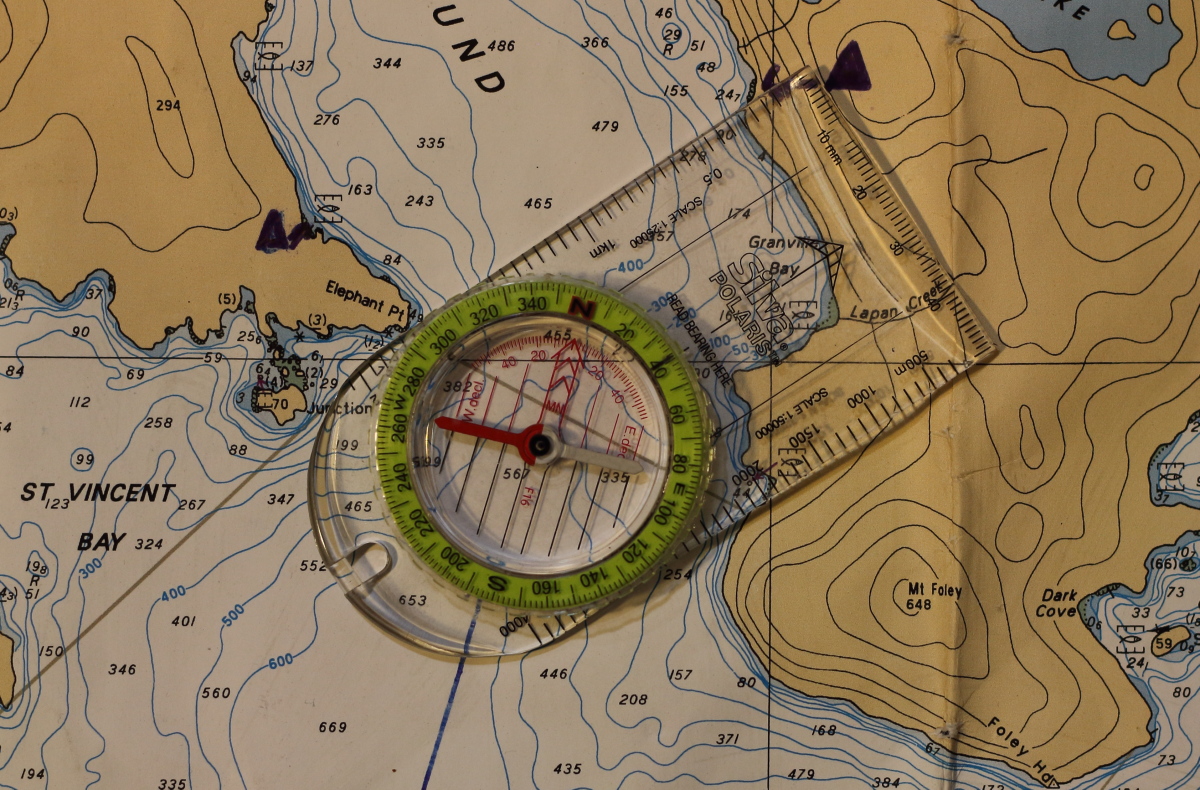
Obviously, a boat that old was a fixer-upper, and I did spend a fair bit of time patching gouges, swapping out the sliding footpedals and guillotine-like aluminum rudder blade for gas pedal pegs and a light, low-drag SmartTrack rudder blade. I also added sail mounts and found a deck compass that could be modified to fit the existing base from the long-lost original compass.
After sea trials to confirm the boat would float (and sail!), it was time to take it on a multi-day voyage.
September 21, 2024
I intentionally arrived at my put-in at Xwawchayay/Porteau Cove in mid afternoon, so that by the time I launched the afternoon inflow winds would be tapering off.
As I packed, one of the onlooking tourists wandered up to me and shot off a long paragraph in what I recognized as German. I had to tell her in English that I didn’t speak German. She switched to English. Her confusion had come from the fact that the spare paddle halves on my kayak deck were clearly labeled “Werner”. But that’s a brand name, not my name. I conscripted her husband to take a prelaunch photo of me, and exhausted my entire German vocabulary to thank him: “Das is gut, donkey-shine!”
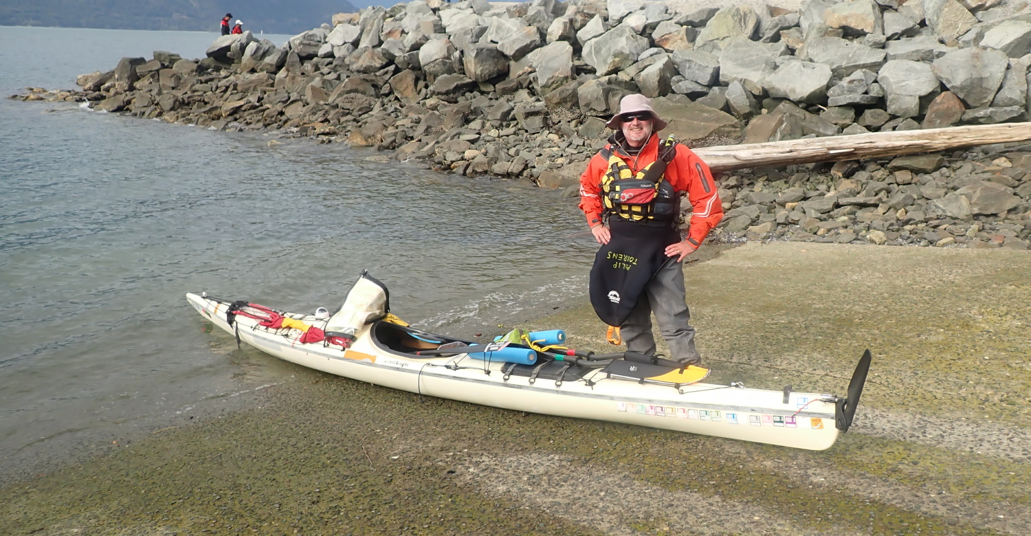
I also briefly puzzled them by soaking down in the outdoor diver’s shower just before stepping into the boat (it was so I wouldn’t overheat in my drysuit on this sunny, warm afternoon.)
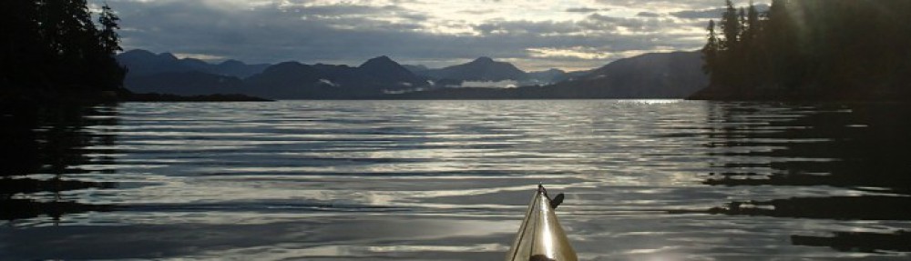
I launched just before 4PM. The fully loaded boat punched easily through the oncoming waves, scattering sun-silvered droplets across my bow. I was fighting the tail end of the inflow wind. As hoped, as I approached the southern tip of Lhaxwm/Anvil Island, the wind eased.

I had the golden hour pre-dusk light bathing Christie Islet as I crossed Ramilles Channel to Gambier Island. I landed at the Inaka Lhaxwm/ Ramilles Channel Recreation Site just before 7PM, to find two other paddlers already in residence. They had, naturally enough, taken the primo tent site with a large flat pad. Since I knew from talking with them they’d be leaving the next day, I set up my tent on a rather lumpy section of the path.
Because I was on a shorter trip, I’d tried something different for my first night supper: a few days before the trip, I’d hit the Chinese takeout buffet at our local T &T market, and filled a container with a selection of my favorites. I’d frozen the container at home and kept it in a cooler bag in my car until just before launching, so it stayed safely cool until I reached camp. As I set up my tent, I reheated my supper in my Outback Oven (a great outdoor cooking gadget that is sadly no longer made.) A delicious novelty to be feasting on Chinese buffet in camp, especially those crispy spring rolls.
Moderate alarms and excursions in the night. I’d been reading in bed, and initially attributed the slight twitches on my legs to muscle spasms. They turned out to be a small mouse scampering over me in search of the egress. After an exclamation (which it turned out was loud enough for my site mates to have heard), I evicted him. I’m sure we both slept better for it.
After that, I slept well, occasionally catching traffic noises from the Sea-To-Sky highway a few miles to the east.
September 22, 2024
In conversation with my two site mates over coffee, it came out that one of them has taken several courses from my employer, Jericho Beach Kayak, from fellow instructors I know well.
As they launched for their trip back to Lions Bay, I took a few photos to email them later (I know from experience it’s always nice to have pictures that include you taken from a bit further away than arm’s length.)

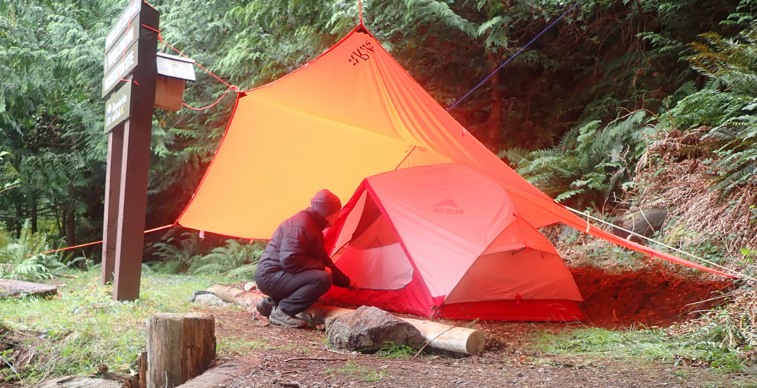
As soon as they had packed up their tent, I pounced on the primo pad for a property upgrade, literally leveling up from my lumpy site of the night before. I spent a happy hour cunningly rigging a super cozy campsite with a tarp over my tent (so nice to have a full porch in front of the tent where you can kneel out of the rain while entering or exiting). I also rigged a large tarp over the picnic table. Thanks to having brought a telescoping tarp pole, I was able to rig the seaside axis of this tarp in a high A-frame, giving me a million dollar view of Ramillies Channel and Anvil Island through the cedar branches. Whether by accident or design, the table is positioned so those trees conceal the cottages on Anvil Island. And the now steady rain created white noise (or perhaps wet noise), drowning out any traffic noises. The two effects combined to create at least the illusion of deep wilderness. Very cool, especially just an hour’s drive from downtown Vancouver.

With a good morning’s work of homesteading done, I settled down to enjoy a brunch of tinned hash and buttered bagel.
As I heated up water for an apres-brunch shower, an open aluminum skiff drifted into view a couple of hundred metres away, with a pair of fishers trolling their rods. Funny how your outlook on exposure changes with age. A half a lifetime ago, when I actually had a body worth ogling, I was pretty self-conscious about it. Today, my take is that if someone is so deprived of stimulation that the sight of my pudgy pink body in the distance is enough to drive them into some sort of erotic frenzy, it would be almost unkind to deprive them of this outlet. So I showered in full view without shyness.
Since there seemed little likelihood of much sunshine–and this site is in the shade much of the time anyway–I set up my candle-powered clothes dryer in the tent. This is basically a three candle lantern, set carefully far enough below the tent gear loft not to melt or burn clothing. I then stacked my drysuit liner in the loft, so the rising hot air would dry it and save me having to climb into clammy layers next time I wore it.

I set out my wok to collect rainwater draining off the tarp. I’d be leery of using tarp run-off for cooking or drinking, but I know from experience it will be fine for washing dishes or self.
In addition to my food, I’ve got my drysuit stored in the critter-proof aluminum cache. Nice to know it’s out of reach of salt-seeking rodents. (Years ago, I had the sweat-seasoned armpits chewed out of a doffed and inverted paddling jacket by mice in the time it took me to eat lunch.)
I spend the rest of the afternoon reading and zoning into that lovely zen state where what Buddists call “the chattering monkey” finally shuts up.
My book is The Ancestor’s Tale, by Richard Dawkins and Yan Wong. It’s a revised edition of the book I read years ago on a circumnavigation of Princess Royal Island.
I supped on tinned beans and molasses. With plenty of rainwater and fuel available, I was able to give the dishes a thorough wash, and not the mere lick-and-a-promise of typical camp cleaning.
I am being buzzed by the occasional mosquito. My mild annoyance is tempered with gratitude that it’s warm enough this late in the season for them to be conducting flight operations.
September 23, 2024
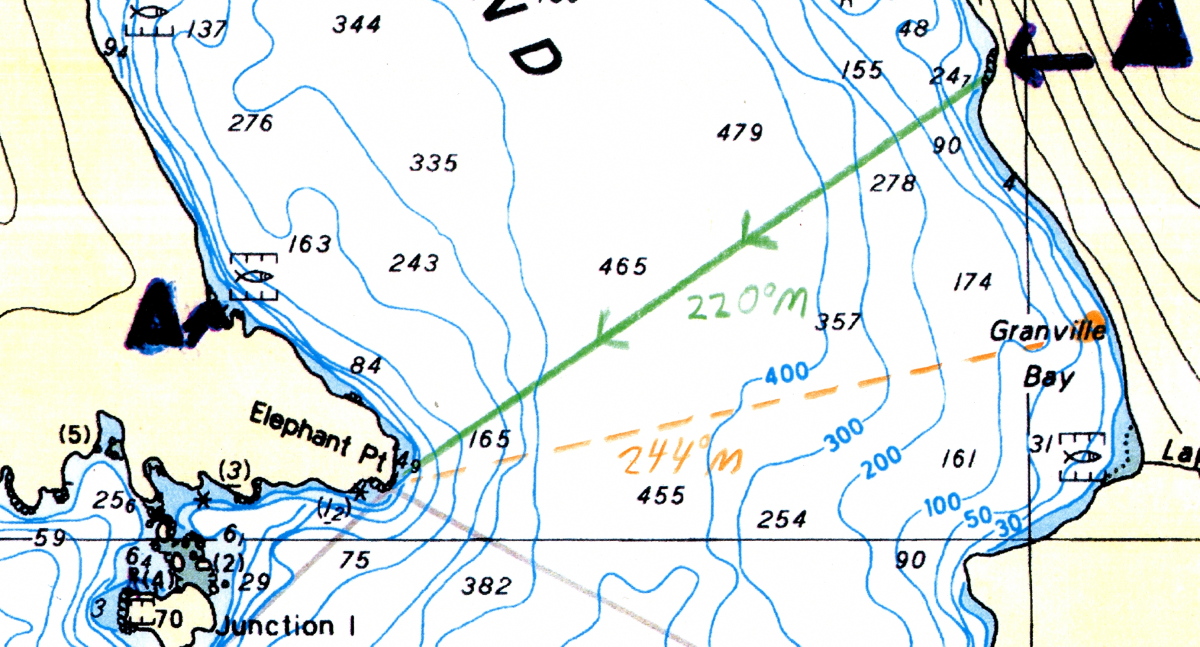
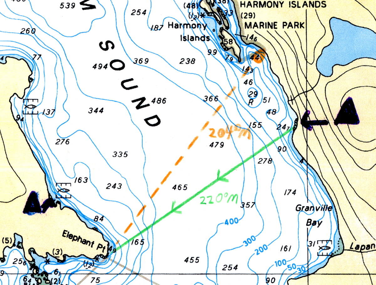
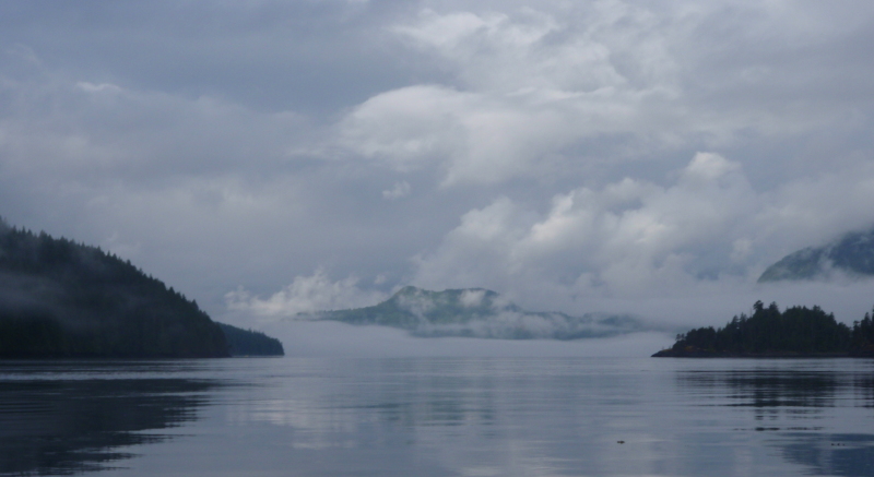
I awoke to low cloud, steady rain and limited visibility. Anvil Island is only a faint shadow looming through the rain. If this persists tomorrow, there won’t be the strong Northbound inflow wind typical of sunny days, and I won’t get my hoped-for glorious free ride back to Porteau Cove, courtesy of my sails. On the plus side, the water would be calm. Navigation would be no problem: in addition to my GPS, I’ve got a hiker’s compass, deck compass and a chart with many of the crossings pre-plotted. I’d aim for Anvil Island, follow its eastern shore to the northern tip, then paddle a compass course aiming off so I’d hit the east shore of Howe Sound south of Porteau Cove, turn left to go North and handrail along the shore to the Cove.
I’m very glad of my folding travel chair. It’s much more comfortable for my not-fully-evolved-for-bipedalism back than the unsupportive bench of the picnic table would be. As always, I’m also happy to have brought what some would have considered a rather selfishly oversized tarp for a solo camper. But on rainy days like these, it’s nice not to have to crouch and prowl under a low, tiny roof. Instead, I have a high ceiling with plenty of head room, and a rain-free area that’s about equivalent to a reasonably-sized room at home. The tarp’s translucent yellow colour creates a warm, vaguely sunlit feel beneath it even on dark days. Add unlimited stove fuel, herbal tea and a good book, and it’s all very cosy.

As I fried up my brunch of pancakes and bacon, I flashed back more than half a century to (under)cooking fatty bacon purloined from mom’s fridge on top of a hobo stove. I’d made this chimney-like contraption out of a large apple juice can following directions from Boy’s Life magazine. It’s a surprise I didn’t die from trichinosis, taking my too-trusting younger sister with me.
There are lulls in the rain during the afternoon. I take advantage of them to explore the site a bit more, finding a second tent pad further in the trees along the path to the east (it would have been too much in the personal space of my site mates to have pitched my tent there on the first night.) Further east still, there’s a beach-access-only site. I’d already noted another cleared site just below the outhouse, but that would be a last resort only option for me: it’s up a steep and slippery climb, which would be even more awkward when portaging gear. Plus, who wants to be serenaded by the sounds of their site mates’ bodily functions in the night?
Although I have other options in my larder, I opt for quick, easy and spicy Korean ramen noodles for supper, with a fruit cup cocktail for dessert to ward off scurvy.

Shades of Robert The Bruce, I fall into a reverie watching a spider whose web hangs off tree branches just beyond my tarp. He’s been patiently sitting in the centre of his web all day. More insects are buzzing about in the gloaming, and soon a hapless fly hits the trap. The spider instantly scuttles towards its victim. We need to avoid anthropomorphizing other animals, but I can’t help but wonder if insects feel something akin to terror when caught like that? Obviously, they wouldn’t experience the full gamut of human emotions, but neither can they be merely the Cartesian automata that ol’ René imagined. But just where on the continuum would they fall?

September 24, 2024

Heavy rains in the night, but I awake to blue sky visible above a low fog. Confident it will burn off, I take my time breakfasting and breaking camp, and launch a bit after 11AM. With visibility now clear, I opt for a dogleg detour to check out Christie Islet. As a Migratory Bird Sanctuary, off limits to boat landings, it swarms with seagulls, cormorants, and seals.

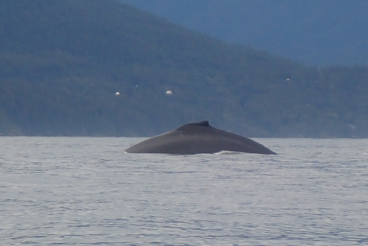
Turning north, I briefly put up my forward, Pacific Action sail. But though I am filled with hope, it is not filled with wind. I am reduced to actually having to paddle my kayak again. The horror! The horror! But I’ll soon be amply recompensed for this loss. As I’d been admiring the birds on Christie, I’d noticed out of the corner of my eye a jetski stopping in the middle of Montagu Channel, north of me. I’d wondered if they’d had a breakdown. As I altered course to swing close and offer to use my marine VHF to call for assistance if they needed it, I discovered the real reason they were stopped: a mother humpback whale and her calf were putting on an amazing show of synchronized swimming, plunging deep, under long enough that they must have been feeding on the seafloor more than two hundred metres below, surfacing with loud huffs and vast plumes of steam, and repeating the process as soon as they’d caught their breath.
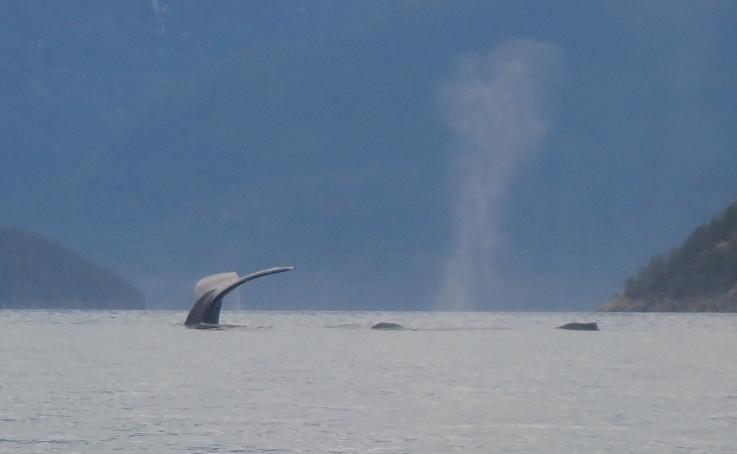
The jetski leaves soon after, but I stay, entranced. An occasional other boat joins me, grabs their requisite social media selfies, then zooms away. But everytime I try to get out, those whales pull me back in. I linger for about two hours, paddling a bit north, drifting south again as I stop to watch them surface, rinsing and repeating. It was magical, visiting with my cousins a few tens of millions of years removed.
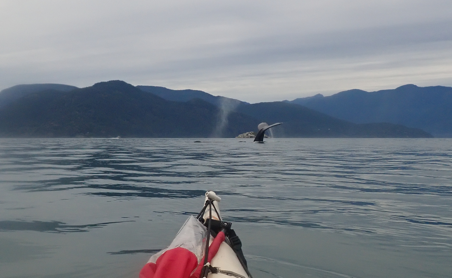
Eventually, I did have to go. I even got to paddle sail for a short while. And I approached Brunswick Point, more whales! Too far away for worthwhile photos, though.
By now it was late afternoon, and the need to pump my personal bilges was becoming ever more urgent. Not wanting my drysuit to become a wetsuit, I landed at the south end of Porteau Cove park, where the walk-in camping sites are, clipped the painter of my kayak to a convenient tree root, and scuttled to the outhouse. Much relieved, I reboarded to paddle the remaining few hundred meters to the boat ramp takeout.
My timing was perfect: the wind was increasingly downchannel as I packed my car and reloaded my trusty kayak, and the rain began to fall just as I finished and got behind the wheel. An excellent four day getaway.
Epilogue: I don’t know whether the original owner of my new-to-me boat simply aged out of kayaking, or whether they’ve gone to the great sea in the sky. Either way, I like to imagine they’d be happy to know their boat is getting out and about once more. Just goes to show that even old sea kayaks–and old sea kayakers–are still good for a few voyages yet!
PSA (Paddler’s Service Announcement): If you are not already a member of the BC Marine Trails Association, you totally should be. Not only does this group inventory all the water accessible campsites along the BC coast, they also help create them, including negotiating access to First Nations land (such as the Inaka Lhaxwm/Ramilles Channel Recreation Site where I camped on this trip. It’s part of the Sea To Sky Marine Trail.) This negotiated access is increasingly important as Canada works its way towards justice regarding the unceded traditional territories of the various First Nations. Thanks to Sḵwx̱wú7mesh Úxwumixw/Squamish Nation for allowing access to their lands, to the BCMTA for helping create these campsites, and to SKABC for maintaining them.


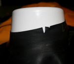 A routine inspection of my paddling drysuit had revealed a pair of notches in the latex neck seal. Stress risers like these will propagate under tension into full tears ̶ usually at the most awkward moment possible, like the first day of a multi-week tour. So it was off with the old and on with the new.
  The picture was a combo pack of cute: a little Inuit girl carrying a squirming husky pup. “That’s a nice doggie you’ve got there.” I said as I crouched down to her eye level. “Yes,” she agreed, then added very matter-of-factly, “but he’s lame, so we’re going to have to shoot him.”