A trip from a time before digital photography.
August 17, 1999 Stania and I were up at 6AM to stow our gear. I dropped her with our kayaks at the Government Wharf in Port Hardy, then bucketed my trusty Escort Wagon over 63 kilometres of logging roads to our takeout on the San Josef River. As arranged, a truck from North Island Transportation picked me up there at 11AM.
Meanwhile, back at the dock, when Stania asked to change in the washroom at the Coast Guard Office, she was welcomed with open arms. She was even invited to take a shower (or perhaps be given one – it wasn’t quite clear). Oddly, when I appeared, I was not offered a shower and only grudgingly allowed to change.
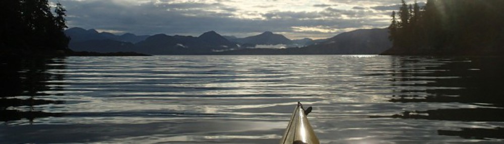
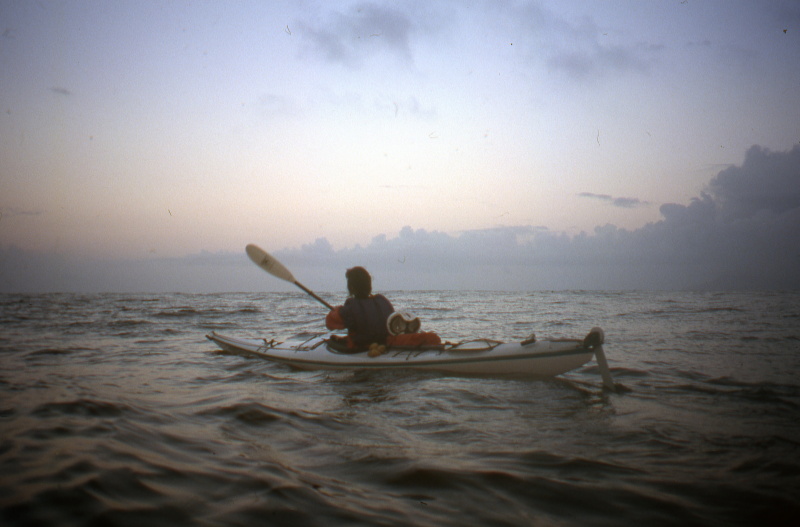
We got underway shortly after 14:00 hours. A moderate wind was blowing up Glotelas Channel and to the Pacific, creating paddling that was lovely and lively with the occasional whitecap, but not in the least threatening. We landed at Songees Creek about 17:00 hours and were lucky enough to have it all to ourselves (it’s a well known spot and popular with tour companies.)
We’ve both been enjoying the novelty of having many hours of daylight in which to make camp and eat dinner – in comparing notes pre-trip, Stania and I found that when we’ve been touring solo, we both have a tendency to push on, and land at dusk tired and hungry. The weather continues to be clear. Any day on the west coast that you are not being rained on is a small victory in itself; Stania has been turning cartwheels down the beach in celebration.
August 18, 1999 Having fallen asleep at 21:00 hours last night, we awoke unprompted at 7:00AM fully refreshed. We enjoyed a bit of sunshine with our pancake breakfast.
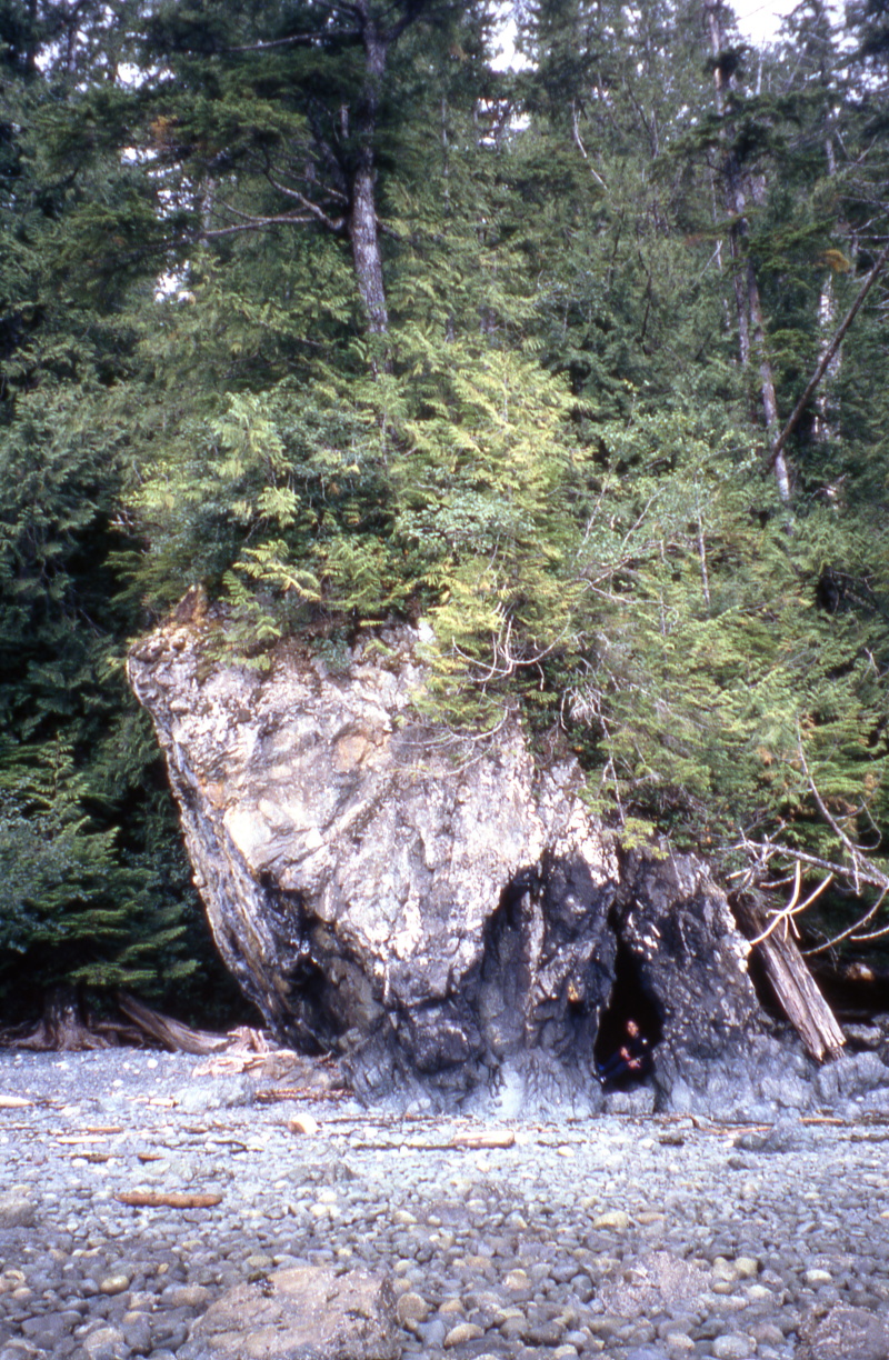
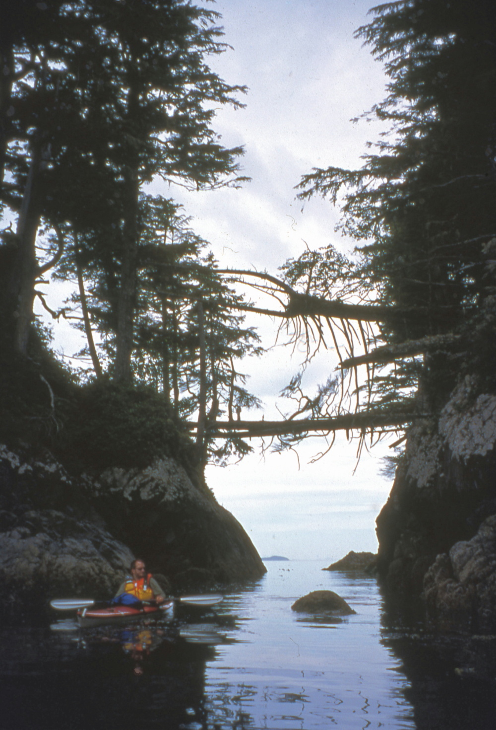
As we followed the south shore of Goletas Channel, we spotted several pocket beaches, all landable in today’s perfect calm. However, none looked campable, and being cobble, they’d be ugly landing in even moderate waves. One had a beautiful twin waterfall and pool and a tall flowerpot island at the other end. The flowerpot featured a cave under construction by the waves, which had carelessly left their tools – assorted rock pestles – strewn about the worksite.
We reached Shushartie Bay about 18:00 hours and hunted for a campsite, rejecting one because of fresh bear scat. After settling on a small beach, and catching the forecast for fog and high winds, our plan is to sleep in and paddle just far enough tomorrow to be in position for a short hop to the Tatnall Reefs.

August 19, 1999 We were woken about nine o’clock by the huffs of Orca passing east to west just offshore of our camp. We paddled through drifting patches of heavy rain, landing to inspect a potential campsite just west of Shushartie Bay. We opted against it, and put to sea just on time to encounter what was probably the same pod of Orca, this time heading east. One exuberant youngster breached several times.
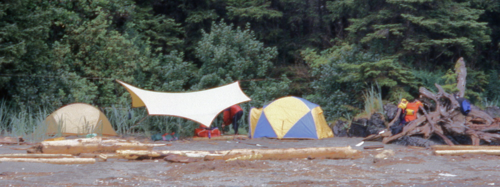
We’ve made camp at the edge of the trees on a small cobble beach. As planned, we paddled only a couple of hours today, so there was plenty of time to fry up last night’s leftover risotto with an onion and enjoy the novelty of a hot lunch on tour.


The afternoon’s weather was a pleasant mix of sun and cloud, with no rain. I ventured out fishing, and after releasing an undersize Ling Cod landed a larger legal one. He is presently in the pot, soaking for dinner. As I write this about 16:30, there are catspaws growing into whitecaps marching west to east in the channel, and banks of fog rolling in from the Pacific.
August 20, 1999 We got up at 6:00AM in order to be on the water by eight. It was critical to hit the Tatnall Reefs by 9:08 when the slack water would change to an ebb.Just around the corner from our rocky, lumpy camp were a series of lovely sandy beaches. Douh!
The weather was cloudy but dry and calm. Opposite Godkin Point we spotted a black bear feeding on the beach. Shortly afterward we began to feel the swell from the open ocean for the first time on this trip – very long and low, but unmistakable.
During the trip planning, we’d identified the Tatnall Reefs as one of the “crux moves” on our route, and we approached them with a bit of apprehension. But the combination of calm weather and timing turned it into a non-event, and by ten o’clock we’d safely traversed the danger zone and were landing in a little nook on the inside of Cape Sutil. Here we had a break and the first installment of lunch, then pushed on the beach at Irony Creek. We landed on this incredibly lovely long arc of sand about 13:00 hours, and had the second half of lunch as we listened to the forecast.
This called for strong to gale force southeast winds. We calculated that being in the lee of the shore, we could continue to make progress. And so we did, until about 15:00 hours when reefs forced us to paddle offshore and out of the lee. Progress slowed to the kayaking equivalent of a hand-over-hand crawl, so we clawed our way to shore. We lucked in on a sheltered patch of beach tucked behind a rocky reef guarded by sea lions. An hour’s work rewarded us with a cozy camp, with our respective tents at either end of the tarp. Good timing on our part, as the rain began bucketing down about 14:30. As I write this about 18:00 hours, we’re snug under our roof and readying a delicious supper of tofu curry with brown basmati rice.
Our paradise has been marred only slightly by the Great Slug Wars. For some unknown reason, these giant (for slugs) creatures decided to gang up on Stania. She turned to find her lunch plate included a distinctly unappetizing added course in the form of a banana slug. Next, she discovered her tent’s inside wall had sprouted a pair of slugs. Definitely inferior decorating. The last straw was finding that her freshly washed underwear, hung to dry, was being slimed by yet another slug. Knowing that salt is kryptonite to slugs, Stania flicked it onto the ground, then, with a terrifying Amazon battle shriek, dropped trou and blasted it with a hot, briney solution. Word seemed to get around quickly; she was unmolested for the rest of the trip.
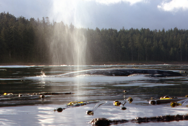
August 21, 1999 After an early bed last night, getting up at 6AM was easy. Plus, we were greeted by blue sky! As we breakfasted, we could see the dorsal fins of several Orca dozing and grazing in the kelp beds just offshore.
As we got underway about 9:00AM, we noticed a whale blowing in the distance, clearly not an Orca, as no dorsal fin was visible. As we rounded Christensen Point, we could see three more series of spouts tracking towards us. We hove to in a kelp bed and watched, equally nervous and excited, as several whales passed by, one within 30 feet of us. We continued toward Dakota Creek. About half way there, we spied two more sets of spouts. One very large whale passed just to starboard of us. As he swam parallel to the swell, we could see the full, impressive length of his body in the troughs.
The beach between Christensen Point and Laura Creek looked incredibly lovely, with sunlight dappling through the trees on to the sand. We landed at Dakota Creek about noon, and lunched on cheese, crackers and leftover curry. About an hour later we launched into a moderate westerly wind. As we landed at Fisherman Bay, I was amused to note the GPS advised us we were only 7.04 nautical miles from our car at the takeout. But that was as the crow flies – portaging and bushwashing our kayaks and gear through ten miles of west coast jungle held no appeal.
We hiked over to the creek just west of Nahwitii Cone, did laundry and bathed in fresh water. Lovely. On the way back we chatted with a family (mom, dad, two kids and a dog) who had backpacked in to this lovely beach.
The weather clouded over in the afternoon, but stayed dry enough for us to dry our laundry, tents and paddling gear. It’s now about 19:15, a gentle sprinkle of rain is pattering on the tarp. Cozy beneath it, Stania and I are writing up our respective logbooks, and enjoying herbal tea and shortbread cookies.
August 22, 1999 Lying in bed til 7 felt like sleeping in after being up at 6 these last couple of days. I explored Fisherman’s Bay a bit, discovering the wreck of a barge the Cape Scott colonists had anchored here in a doomed attempt to make this an all-weather port.
After a leisurely pancake breakfast, we put to sea about noon. Rounding Frederiksen Point, we had an unobstructed view of the Scott Islands and our first view of Cape Scott. As we’d hoped, we were able to tuck into a tiny sheltered area amid the rocks at the western end of Nels Bight. At the time, the low surf would have permitted landing anywhere along the bight, but this area will permit the easiest launching in any conditions.

We’ve set up a beautiful camp within yards of where we came ashore. The western third of the beach is dotted with the tents of backpackers. Since we’d landed before 14:00, we had plenty of time to stroll to the eastern end of the beach and back, revelling in the sunshine.

As it was my night in the galley, I baked up a hearty cheese pizza, topped off with some bratwurst from Stania’s larder. (During our afternoon stroll, we’d speculated that in a survival situation you might be able to make sausage out of the numerous tiny birds that scamper along the water’s edge. However, we’d really rather not take a tern for the wurst.)
We fell asleep happy to be at the perfect jumping off point for rounding the cape.
August 23, 1999 About 11AM, we set out on foot for Cape Scott, following the hiking trail from the western end of Nels Bight. Our route took us along the rugged and beautiful Experiment Bight, and past a ruined cabin, before emerging on to the beach at Guise Bay. We were pleased to see that the bay appears to be landable, at least in the current weather.

We carried on to the lighthouse over an old twin lane trail that may have been a Jeep road between the WWII barracks at Guise Bay and the radar station at the cape. A sign described the fate – as far as it is known – of the Maggie Mac, a sailing sealer lost in 1892 with all hands.


The light station was a cluster of well maintained white buildings, including a greenhouse. As we stood on the helipad admiring the view, Cape Scott lived up to its reputation: a wall of fog cascaded down the valley between the cape and Hansen Bay.
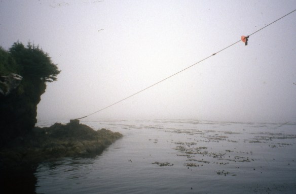
Exploring another fork in the road, we found the cable car station used to unload supply boats for the lighthouse. As we ate our lunch there, the fog closed in still further, until visibility was only about 400 feet.
Though it was calm, you can certainly understand how in the days before radar and GPS, vessels often failed to stay on the twisting, variable width safe path between the rocks and reefs and the offshore tide rips of Scott Channel.

August 24, 1999 As we’d agreed last night, we got up at 6:00AM to listen to the weather forecast and make the go/no go call about rounding the cape today. It had been raining heavily through the night and the prediction was for moderate winds from the south, rising to gale force. In addition, my barometer had dropped steadily through the night. So although we probably could have snuck around the cape, especially if we’d been prepared to land in Guise Bay, we opted to wait it out. Our plan is to paddle from here to Hansen Bay, so we’d like a longer window of good weather. Back to bed we went. Before I woke for the second time, I had vivid dreams of the sinking of the Maggie Mac, seeing her descend through endless emerald depths.
Once we were up for keeps, I assembled a huge brunch of hash browns, bacon and scrambled eggs, washed down with lashing of coffee (one the pleasures of non-paddling days is being able swill coffee without worrying about the fact you’ll need to pee hourly.)
As I write this entry about 12:30PM, we are sitting cozily under the tarp in a steady rain and feeling very vindicated about our decision to stay: the surf breaking on the beach is increasing in height and frequency, spindrift is blowing off the wavetops out to sea, and the barometer continues to plummet.
Stania returned from an expedition to the outhouse, where she had encountered a shivering young backpacker changing into her last dry T-shirt. (Not everyone takes seriously the park’s warning to bring near-winter gear even in summer.) The only thing that kept Stania from handing over her fleece jacket was the knowledge we still have many days to paddle ourselves.

Later: Stania and I discovered the steady rain had saturated the sand beneath our tents so that they now stood in pools of water. Extensive ditch digging operations failed to create adequate drainage, so we’ve moved both tents a few feet higher up the beach, on to the lumpier but drainier gravel.
Yesterday, we’d noticed the occasional whiff of hydrogen sulfide, we assumed from decaying seaweed buried in the sand. Today’s prolonged rain has leached a lot more of it out of the ground, and the odour is quite pronounced at times.
Although I’m used to and am prepared for long periods of rain from all my solo touring, I’m glad of Stania’s company. She’s used to it from her own solo touring, so she’s not complaining, and we both find it helps to be able to share a wry joke about the weather.
The second part of this trip report is here.

Pingback: Sea Kayaking Around Cape Scott, Part 2 | Kayakwriter's Blog